إدارة الحفاظ على البيئة والترفيه إدارة الحفاظ على البيئة والترفيه
احفظ. احمِ. استمتع.
شعار DCR
قائمة الجوال
ابحث في موقع DCR
Facebook Twitter YouTube انستغرام LinkedIn
حول DCR
 
المتنزهات العامة
 
التراث
الطبيعي
حماية التربة والمياه
الاستجمام
التخطيط
سلامة السدود و
السهول الفيضية
حفظ
الأراضي
  • سلامة السدود والسهول الفيضانية
  • المنح والتمويل
    • صندوق المساعدة لسلامة السدود والوقاية من الفيضانات والحماية منها
    • المنح والقروض المقدمة من صندوق التأهب للفيضانات في المجتمعات المحلية
    • صندوق القرض المتجدد المرن في فيرجينيا
  • سلامة السدود
    • وثائق إرشادات سلامة السدود
    • جهات اتصال سلامة السدود
    • تصنيف السدود
    • لوائح سلامة السدود (PDF)
    • التثقيف بشأن سلامة السدود
      • السدود 101
      • أعطال السدود
      • يوم التوعية بسلامة السدود
      • أكاديمية ASDSO لمالكي السدود
      • موسم الأعاصير
      • التوعية بسلامة السدود
    • التدريب على سلامة السدود
    • صندوق المساعدة لسلامة السدود والوقاية من الفيضانات والحماية منها
      • 2025 قائمة المنح الممنوحة (PDF)
      • 2024 قائمة المنح الممنوحة (PDF)
      • 2023 قائمة المنح الممنوحة (PDF)
    • نظام جرد سلامة السدود (DSIS)
    • دراسة الحد الأقصى المحتمل لهطول الأمطار المحتمل وأداة تقييم PMP
    • خلفية دراسة الحد الأقصى المحتمل لهطول الأمطار
    • ورقة عمل تحليل التوزيع الزمني والحسابات الزمنية
    • الغطاء النباتي، التآكل
    • مكافحة القوارض
    • النماذج
  • السهول الفيضانية
    • في. برنامج إدارة السهول الفيضية
    • لوائح ومراسيم السهول الفيضية
    • نظام فيرجينيا لمعلومات مخاطر الفيضانات
    • الوظائف الطبيعية للسهول الفيضانية
    • نظام التصنيف المجتمعي
    • موارد إدارة السهول الفيضانية
    • التوعية بالفيضانات في فيرجينيا
      • أسبوع التوعية بالفيضانات
      • موارد التوعية
    • جهات اتصال السهول الفيضانية
    • تمويل القدرة على مواجهة الفيضانات
      • المنح والقروض المقدمة من صندوق التأهب للفيضانات في المجتمعات المحلية
        • قائمة منح مؤسسة CFPF
      • صندوق القرض المتجدد المرن في فيرجينيا
  • تخطيط القدرة على مواجهة الفيضانات
    • الخطة الرئيسية للحماية من الفيضانات في فيرجينيا
      • شارك معنا
    • الخطة الرئيسية لمرونة سواحل فيرجينيا الساحلية
      • إطار عمل التخطيط الرئيسي لمرونة السواحل
      • الخطة الرئيسية لمرونة السواحل، المرحلة 1
      • الخطة الرئيسية لمرونة السواحل، المرحلة 2
      • مستكشف الويب الخاص بالمرونة الساحلية
      • بوابة مستخدم مستكشف الويب
    • التوعية والمشاركة
    • التقويم والتدريب والفعاليات
    • اللجنة الاستشارية لمقاومة الفيضانات
    • الاجتماع التنسيقي السنوي للتأهب للفيضانات
    • بوابة البيانات المفتوحة
    • الموارد والتقارير
  • التقويم والتدريب والفعاليات
  • مركز بيانات نظام المعلومات الجغرافية المفتوح
  • شارك قصتك الفيضان
الرئيسية " سلامة السدود والسهول الفيضانية " موارد وتقارير تخطيط القدرة على مواجهة الفيضانات

Flood Resilience Planning Resources


Flood Hazard Data

Understanding flood risk requires knowing which areas of your community are exposed to flooding today, and which areas are expected to be exposed in the coming decades. Due to changing patterns of precipitation, sea level rise, and development, historic flooding trends are no longer a useful predictor of future risk.

Nationwide, we lack consistent, locally specific data that forecasts flooding based on multiple risk sources. The Commonwealth is closing these data gaps and providing data tools to support flood resilience planning efforts in Virginia.

DCR flood data

DCR provides two non-regulatory flood hazard datasets that can be used together with regulatory data to support more informed flood resilience planning: a coastal Virginia flood hazard dataset (developed for the Coastal Resilience Master Plan) and a statewide Fathom flood hazard dataset (procured for the Virginia Flood Protection Master Plan). The table below explores and compares these two resources.


Coastal Virginia Flood Hazard Data

Fathom Flood Hazard Data

Geographic Area

Coastal: localities within any of the eight easternmost Planning District Commissions in Virginia.

Statewide: The entire Commonwealth of Virginia.

Flood Hazards

Coastal, riverine, and rainfall-driven flooding

Coastal, riverine, and rainfall-driven flooding

Recurrence Intervals

Seven recurrence intervals: 1 in 2-, 5-, 10-, 25-, 50-, 100-, and 500-year.

Three tidal conditions (MLW, MHW, 1.5xMTR) are also available for coastal flood data.

Five recurrence intervals*: 1 in 10-, 25-, 50-, 100- and 500-year.

Associated DCR Plan

Coastal Resilience Master Plan (CRMP)

Virginia Flood Protection Master Plan (VFPMP)

Planning Scenarios

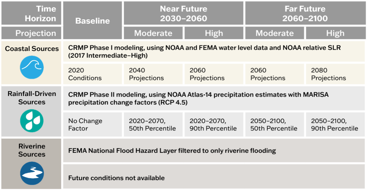
Five planning scenarios: baseline (2020), plus “moderate” and “high” scenario options for the near future (2030-2060) and far future (2060-2100) time horizons.

Five planning scenarios: baseline (2020), plus two “moderate” and “higher” scenario options for the 2060- and 2100-time horizons.

Basis for Future Conditions

Varies by flood source and planning scenario. See reference figure for more information.

Shared Socioeconomic Pathway 2-4.5 (SSP2-4.5). “Moderate” scenario based on median (50th percentile) values and “higher” scenario based on 83rd percentile values.

 قرار

10-foot

10-meter (~33-foot)  

Source

DCR with underlying data from the United States Army Corps of Engineers, the National Oceanic and Atmospheric Administration, and the Federal Emergency Management Agency.

Fathom

وصول

View and download data and methodology documentation via DCR’s Flood Resilience Open Data Portal.

View the 1 in 100- and 500-year data for baseline conditions via DCR’s Flood Resilience Open Data Portal.

Access to all other products is provided to VA public institutions.*

معلومات إضافية

Learn more via the one-pager.

Learn more via the one-pager.

*Virginia government entities and state-recognized Tribal governments may sub-license all Fathom data from DCR for a 12-month renewable license term. To inquire about a sub-license agreement, including data use limitations, please contact us at flood.resilience@dcr.virginia.gov.

Other flood data

Additional data to visualize and understand flood hazards is available through state and federal platforms. Below is a snapshot of these data resources which can be accessed through the links provided.

  • FEMA Flood Hazard Data via DCR’s نظام فيرجينيا لمعلومات مخاطر الفيضانات (VFRIS) – VFRIS compiles and displays flood hazard data from the Federal Emergency Management Agency (FEMA) including Special Flood Hazard Areas. It also provides access to links to download FEMA Flood Insurance Studies, FEMA HEC-RAS Models. These maps also display non-regulatory flood hazard data including data from  and data do not incorporate future-looking projections based on changing precipitation patterns, new development or compound flood risk from tidal flooding events.

  • National Hurricane Center’s Storm Surge Risk Maps – includes data viewers and data downloads based on modeling which forecasts the extent and depth of storm surge resulting from hurricanes (category 1-5) for the Virginia coast. 

  • NOAA 2022 Sea Level Rise Technical Report – provides nationwide forecasts for sea level rise through 2150. The report provides more recent forecasts than were included in DCR’s coastal resilience web explorer and Phase I of the Coastal Resilience Master Plan. NOAA’s Sea Level Rise Viewer allows users to map and download the data.

  • NOAA Mid-Atlantic RISA Projected IDF Curve Data Tool – county-level tool for forecasting changes in precipitation depths from historic ATLAS-14 modeling to two future conditions (2020-2070 and 2050-2100) under two emissions scenarios (RCP 4.5 and RCP 8.5). The model forecasts precipitation change across six average recurrence intervals (2-year to 100-year) and 14 durations (5 minute to 7 day).

Tools for Planning

There are many tools to aid organizations in crafting a flood resilience plan. Below is an abbreviated list of useful planning tools. Additional tools can be found on the information gateways linked below.

Tools specific to Virginia

The following tools were developed with Virginia-specific needs in mind. While some are focused on exploring flood resilience specifically, others support resilience planning more broadly.

  • CFPF Resilience Plans - a DCR-approved Resilience Plan is required for localities submitting applications in the "project" category of the Community Flood Preparedness Fund. The requirements for an approved resilience plan can be found in Appendix F of the CFPF Grant Round 6 draft manual.
  • ADAPT VA – an information gateway on climate change adaptation for individuals, local programs, and agencies in Virginia. The website provides a variety of resources such as short and long-term sea level curves and maps, flood mapping and decision-support tools, legal and policy resources, and stories that explain adaptation through maps and pictures.
  • Proactive Planning for Resilience: Protocols for Community-Led Climate Adaptation Planning in Virginia – a Virginia-specific guide for climate adaptation planning for decision-makers across the Commonwealth. The website outlines steps for developing a plan, with detailed case studies, definitions, tools, legal considerations and best practices.
  • The RAFT and PREP Tool – The Resilience Adaptation Feasibility Tool (RAFT) Team is a Virginia state university partnership which brings capacity building and technical assistance to local governments over a period of 18 months to help build their resilience. Their team’s PREP Tool provides access to the RAFT’s methods and approach for assessing local government capacity for resilience and identifying and prioritizing projects to implement.

Federal Tools

Federal agencies have developed tools to assist organizations to plan and implement successful flood resilience strategies. The following resources may help you to craft your resilience plan.

  • US Climate Resilience Toolkit – a national portal that includes a variety of tools for building resilience to flooding impacts, including the Steps to Resilience Framework, which outlines a straightforward process for creating a resilience plan alongside resources to use to get there.
  • USACE’s International Guidelines on Natural and Nature-Based Features for Flood Risk Management – consolidates best practices for constructing natural and nature-based features for flood risk management into a guidance document for decision-makers and practitioners to use when considering these practices in flood resilience plan development.
  • US DOI Nature Based Solutions Roadmap – outlines information on nature-based solutions, including specific strategies, considerations for implementation, co-benefits, examples, and resources.

بوابات المعلومات

These portals and databases contain a variety of resources – such as data, planning tools and funding information – that may be useful to your organization as you develop your resilience plan:

  • مكتبة موارد التعافي والمرونة التابعة للوكالة الفيدرالية لإدارة الطوارئ الفيدرالية
  • Association of State Floodplain Managers’ Library
  • المؤسسة الوطنية للحياة البرية، قاعدة بيانات تمويل الحلول القائمة على الطبيعة

تمويل التخطيط والتنفيذ

Organizations developing flood resilience plans should consider approaches which align both with DCR’s flood resilience plan guidance, as well as with federal resources and funding opportunities. Resources to help you understand how to align your approach to resilience planning with available funding resources include:

DCR Flood Resilience Funding Resources

DCR administers the Community Flood Preparedness Fund (CFPF) and the Resilient Virginia Revolving Fund (RVRF).  For more information on these funds visit the DCR Floodplain Management, Flood Resilience Funding website.
Beyond the DCR administered resilience funds, the Coastal Resilience Web Explorer Funding Opportunities tab provides an inventory of funding sources that may be available to finance the development and/or implementation of your plan. While it is catered to the coastal region, non-coastal activities may be eligible for some listed opportunities.
The DCR Flood Resilience Funding Geographic Focal Area Viewer identifies geographic areas that are designated as either required or preferred for resilience funding, including Low-Income Geographic Areas for the DCR Community Flood Preparedness Fund.

Other Funding Resources

  • الوكالة الفيدرالية لإدارة الطوارئ (FEMA) وإدارة الطوارئ في فيرجينيا (VDEM)
    • إرشادات الوكالة الفيدرالية لإدارة الطوارئ الفيدرالية (FEMA) للمساعدة في التخفيف من المخاطر
    • معلومات برنامج منح VDEM
    • خطة كوفا للتخفيف من المخاطر
  • سلاح المهندسين بجيش الولايات المتحدة (USACE)
    • Flood Risk Management Mission to learn more about the Corps’ available assistance programs.
    • Division and District Information to determine the appropriate point of contact to learn more.  USACE is broken into watershed-based divisions and districts.
  • آخرون
    • American Flood Coalition Flood Funding Finder
    • U.S. Climate Resilience Toolkit Funding Resources

التقارير

يتم أرشفة التقارير التاريخية ذات الصلة بالتخطيط لمقاومة الفيضانات في فرجينيا عبر القوائم المنسدلة أدناه.

2025 تحديث حالة المرونة في Commonwealth of Virginia

خلال جلسة الجمعية العامة 2024 ، قام مشروع القانون 1458 بتعديل متطلبات تقرير حالة مرونة الفيضانات في قانون ولاية Virginia (§ 2.2-220.5) لتشمل حالة المرونة الشاملة في Commonwealth، بما في ذلك مرونة الفيضانات. يتم إصدار التقرير في يوليو 2025 وكل عامين بعد ذلك، ويتضمن التقرير حالة الإجراءات التي اتخذها كبير مسؤولي المرونة والوكالات الحكومية فيما يتعلق بتنسيق المرونة والتخطيط وجميع تمويل المرونة الذي تلقاه Commonwealth ووزعه خلال العامين السابقين.

اقرأ تحديث حالة المرونة في Commonwealth of Virginia2025

2023 Resilience Coordination Working Group Report

خلال جلسة الجمعية العامة 2024 ، قام مشروع القانون 1458 بتعديل متطلبات تقرير حالة مرونة الفيضانات في قانون ولاية Virginia (§ 2.2-220.5) لتشمل حالة المرونة الشاملة في Commonwealth، بما في ذلك مرونة الفيضانات. يتم إصدار التقرير في يوليو 2025 وكل عامين بعد ذلك، ويتضمن التقرير حالة الإجراءات التي اتخذها كبير مسؤولي المرونة والوكالات الحكومية فيما يتعلق بتنسيق المرونة والتخطيط وجميع تمويل المرونة الذي تلقاه Commonwealth ووزعه خلال العامين السابقين.

  • تنزيل التقرير النهائي والتوصيات الكاملة لمجموعة عمل تنسيق المرونة
  • تنزيل التوصيات النهائية المختصرة لمجموعة عمل تنسيق المرونة

قام مركز جامعة فرجينيا كومنولث للسياسات العامة (CPP) بتيسير أعمال الفريق العامل المعني بمقاومة الفيضانات المتكررة بدعم مالي من مركز الكومنولث لمقاومة الفيضانات المتكررة (CCRFR).

2023 تقرير حالة القدرة على مواجهة الفيضانات

في 2023 ، نشر كبير مسؤولي المرونة في الكومنولث تقريرًا كل سنتين إلى الحاكم والجمعية العامة عن حالة القدرة على الصمود في مواجهة الفيضانات في فرجينيا وفقًا لقانون فرجينيا (§ 2.2-220.5).

اقرأ تقرير2023 عن حالة مقاومة الفيضانات.

الصفحة الرئيسية » سلامة السدود وإدارة السهول الفيضية » تخطيط مرونة الفيضانات
إدارة الحفاظ على البيئة والترفيه في فيرجينيا
600 East Main Street, 24th floor | Richmond, VA 23219-2094 | 804-786-6124
Please send website comments to web@dcr.virginia.gov
Address general inquiries to pcmo@dcr.virginia.gov
Copyright © 2026, Virginia IT Agency. All Rights Reserved
Last Modified: Wednesday, 21 January 2026, 10:38:47 AM
تقارير الشفافية الخاصة بـ eVA استعرض نفقات إدارة الحفاظ والترفيه في فيرجينيا.
اتصل بنا | مركز الإعلام | سياسة الخصوصية | إشعار ADA | FOIA | وظائف | مدونة الأخلاقيات (PDF)
مخطط الهيكل التنظيمي لـ DCR (PDF) | الخطة الاستراتيجية (PDF) | تقرير التقدم التنفيذي (PDF) | السلامة العامة وإنفاذ القانون